Western Australia is a wonderland for anyone seeking an outdoor adventure and offers plenty of challenging four-wheel driving tracks just waiting to be explored.
So, to help you plan your next adventure, we’ve compiled a guide to five top-favourite tracks to tackle with your 4WD and camper.
Please note, many of these tracks are very challenging and desert driving experience is required. Always research and plan your route ahead of time, as the tracks can cover vast distances where food, water and supplies cannot always be sourced.


Abide by all rules regarding towing camper trailers and ensure you allow plenty of time to organise any required permits.
When heading into remote places it’s important to make sure you’ve got all the necessary gear when heading out. Plan your route and make sure you’ve got enough food and water for each person you’re travelling with. It’s advised to have emergency food and water packed as well — at least 72 hours’ worth per person is wise, but more if you have the room and weight capacity.
Carry a sensible range of spare parts to suit your vehicle and camper, including two spare wheels and tyres and tyre repair equipment such as a Tyre Plier Kit.
Ensure you have the right communication devices including a UHF radio to speak to any nearby vehicles, as well as a satellite phone and personal locator beacon (PLB) for emergencies. A first aid kit is also advised.
When travelling, put a red sand flag on your aerial. This, along with your UHF radio, will help alert other travellers of your presence.
1. Anne Beadell Highway
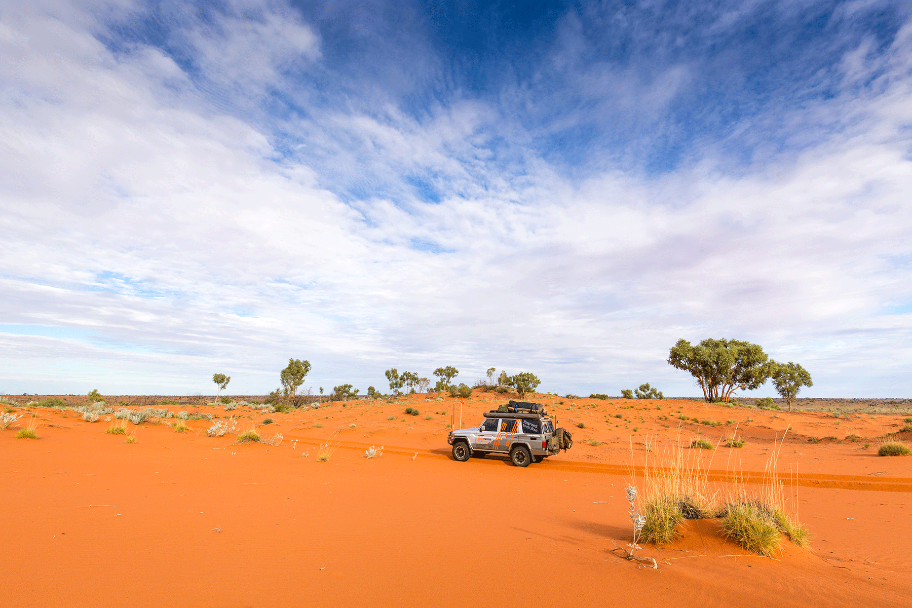
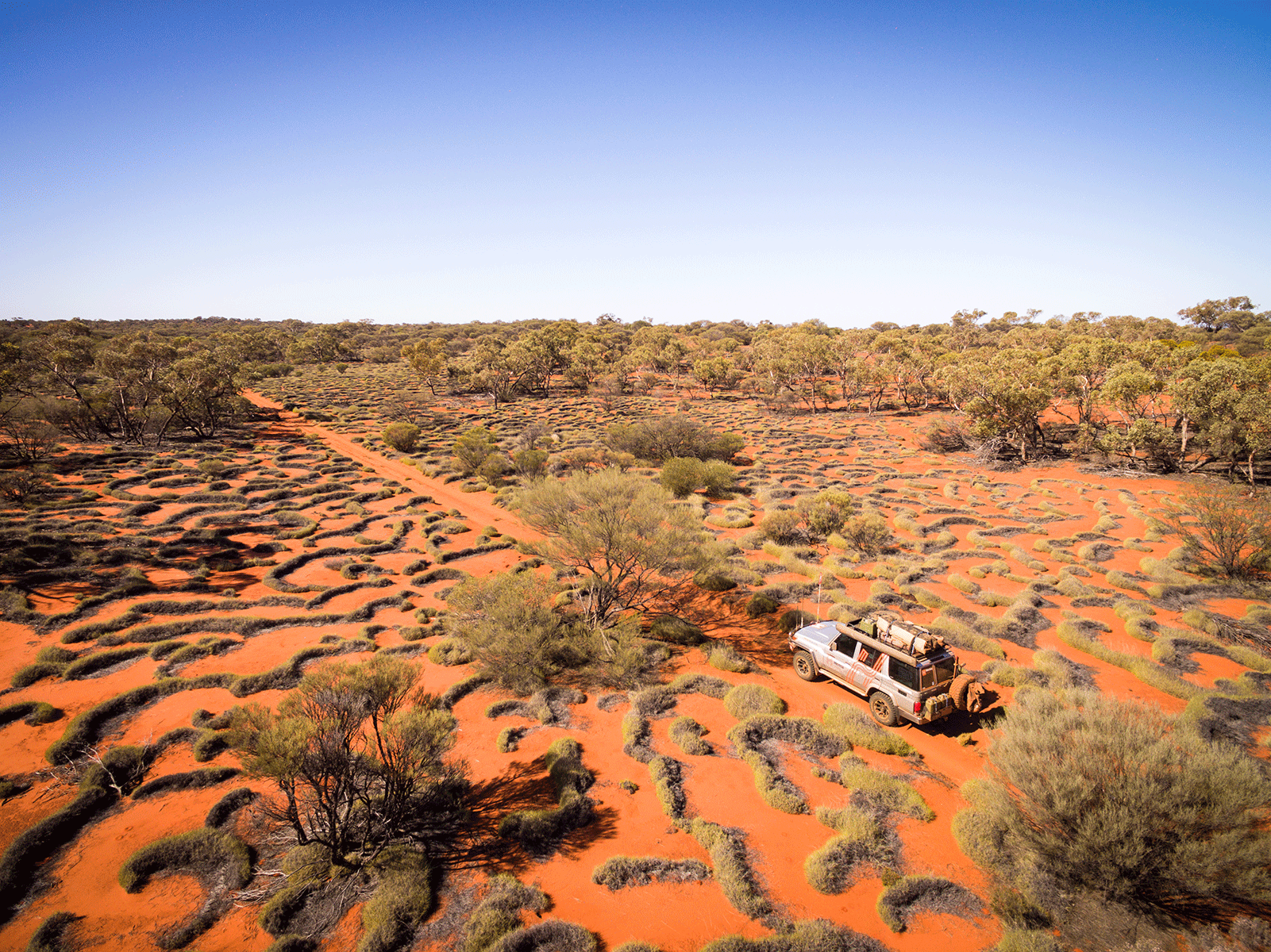
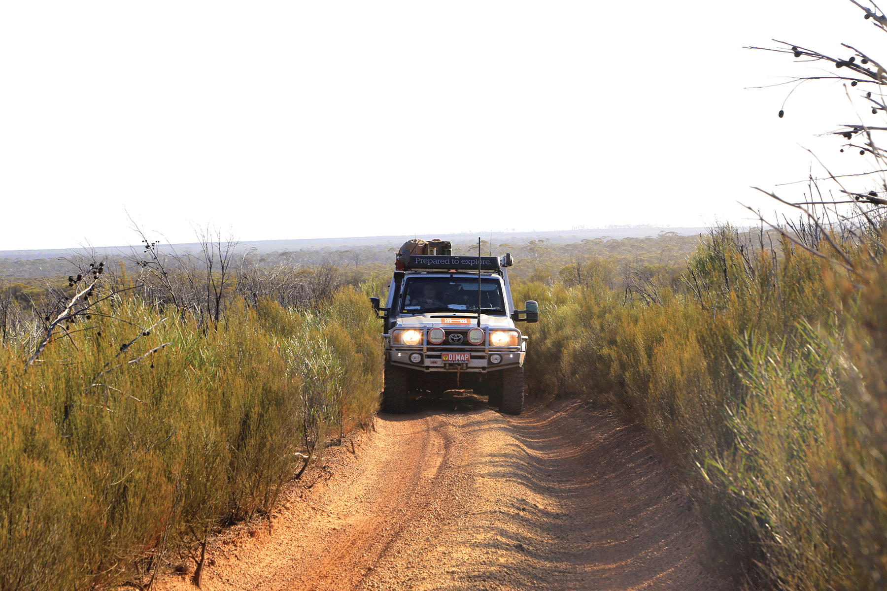
If you’re looking for a remote outback track, then the Anne Beadell Highway is one of the best. This track was named after Len Beadell’s wife, and runs between Laverton, WA, and Coober Pedy, SA, traversing approximately 1380km. The route takes you through some stunning landscapes, including the largest dune desert in Australia — the Great Victoria Desert.
Please note, this is an extremely remote track and should not be undertaken alone unless you are an experienced desert traveller.
 (Image Matt Williams)
Covering 818km from Ilkurlka Roadhouse to Coober Pedy, the Anne Beadell Highway takes approximately one week and is graded medium. Camper trailers are permitted but travel sensibly.
There aren’t many places to stock up on food and fuel along the way, so pack accordingly and utilise Ilkurlka Roadhouse before you depart.
Avoid the summer months as temperatures are extremely high. The best time of year to travel the Anne Beadell Highway is May to September — but remember, temperatures can drop below freezing so plan accordingly.
The journey
If you’re starting from the west, then Laverton, WA, will be your kick-off point. There are some great sites to see in this historic gold-mining town, including the Laverton Great Beyond Explorer’s Hall of Fame.
Located in the Great Victoria Desert, 200km north of Laverton, Yeo Lake Nature Reserve includes the impressive Yeo Lakes system. The summit of Point Sunday provides spectacular views across the landscape and is well worth the walk.
Neale Junction is where the Anne Beadell track and Connie Sue Highway meet. This is a good place to stop for a rest if needed. As you head further along the Anne Beadell, ther4e is a short detour that will take you to a light aircraft wreck of a Goldfields Air Services flight that crashed in 1993. The wreck is north of the Anne Beadell, and 59km west of Ilkurlka.
Located in the heart of the local Tjuntjuntjara country, the Ilkurlka Roadhouse has plenty to offer in terms of cultural and environmental displays. The Roadhouse sells cultural artefacts that make great travel mementos. There’s also fuel and camping facilities, including showers. The tracks to the north and south of the roadhouse are not accessible to the public.
Heading towards the SA border, the Serpentine Lakes is a long series of salt-encrusted lakes and marks an ancient drainage basin that ran down to the Great Australian Bight. There are some basic amenities on western side of these lakes, and it is here that the WA and SA borders meet.
If you follow the track south of the amenities, you’ll find a large rock or gnamma hole named Djindugara, where Len Beadell’s grandson Mitchell was christened in July 1992.
Further east of Serpentine Lakes the gibber plains slowly transform into the sandy desert. Sand dunes become more frequent and larger, so adjust your tyre pressures accordingly. When you are approximately 49km from Voakes Hill Corner, the track takes you up a rise which offers fantastic views east across what appears to be an endless woodland of oak and shrubs. Continue along the track to Voakes Hill Corner, where there is a track that heads south to Cook on the Trans-Australian Railway.
Continue east to enjoy some of the Great Victoria Desert’s most beautiful dune formations and vegetation.
Head past Anne’s Corner, and then west of Emu you’ll find a turnoff to Emu Claypen, which is named for the footprints found on its surface.
It’s safe to visit the Emu atomic bomb testing sites, Totem 1 and Totem 2, which date back to October 1953. At both locations there are concrete obelisks that mark where the detonation towers once stood. At the obelisks you can see samples of stone transformed into ‘glass’ by the heat of the blasts.
You can see the change in vegetation pattern and structure when approaching Emu from either direction — trees and woodland give way to low scrub line, demonstrating the extent of the fire-zone.
East of Emu, the Anne Beadell passes through rolling plains of grass and shrublands — the swales between dunes are broad and crossings are made at an angle.
The iconic Coober Pedy is the eastern ‘jumping off’ point for the Anne Beadell Highway, and well worth exploring once you’ve arrived.
Permits and fees
If you’re travelling the Yamarna to Neale Junction section, you’ll need a transit permit from the Department of Planning, Lands and Heritage (DPLH), which can be found here.
You’ll also need a permit from Maralinga Tjarutja Incorporated. Allow four to six weeks for processing.
P: 08 8625 2946
E: reception@maralinga.com.au
Depending on where you plan to travel in the Woomera Prohibited Area (WPA) you may require a Tourist Permit.
Visiting Mamungari (Unnamed) Conservation Park doesn’t require a Desert Park Pass, but if you want to camp there you will need a camping permit. A Desert Parks Pass and camping permit are required for Tallaringa Conservation Park.
For information on alcohol restrictions in the area, go here.
Contact details
Coober Pedy Visitor Centre
P: 08 8672 4617
Ilkurlka Roadhouse
P: 08 9037 1147
Tjuntjuntjara Community
P: 08 9037 1100
The Great Beyond Visitor Centre
P: 08 9031 1361
2. Canning Stock Route Track
The Canning Stock Route (CSR) is one of the most challenging 4WD tracks in Australia, and while there is no rule against towing a camper along it, many advise against it and opt for RTT or swags instead. The track isn’t just demanding on the tow vehicle or rig and requires a lot of physical endurance to withstand the conditions and corrugations. It’s best to do this route with multiple people or as part of a Tag-Along tour.

The track follows the route created by Alfred Canning in 1906 (approximately) and covers almost 1600km. You’ll see a lot of historic sites along the way, including 51 wells.
You need to research your trip thoroughly before hand and be completely self-sufficient with all emergency equipment packed. Like the Anne Beadell track, ensure you’ve got plenty of water.
In sand dune country, vehicles should have a sand flag installed for extra visibility for oncoming vehicles. And pack a strong bucket with a handy and a long rope to access water from the wells.
Camping is not allowed at all the wells along the way, so check for the latest information before you depart.
The CSR will take between two and three weeks to complete. The stretch of road between Wiluna and Kunawarritji (963km) is the longest distance without fuel, so plan accordingly.
The best time of year to tackle the CSR is between May and September.
The journey
There’s plenty of history to see along the iconic CSR track. It follows a route once used by cattle, horses and stockmen and you’ll be able to spot grave sites at many of the wells along the way.
The well’s mark Alfred Canning’s original purpose when creating the CSR. Most wells are in disrepair, but several have been resorted and give visitors a good idea of what the original CSR looked like. They’re fascinating to see and offer a glimpse into this part of Australia’s rich outback history.
Near Well 40 you’ll find the grave of Michael Tobin, a member of Canning’s original party who was fatally speared in 1907. During the incident Tobin shot and killed Mungkututu, the Aboriginal man who had speared him. Mungkututu’s grave can also be found near the well.
Well 37 is also known as the ‘Haunted Well’ due to the number of grave sites that surround it, including the graves of drovers Christopher Shoesmith, James Thompson and an Aboriginal stockman known as Chinaman.
Due to the length of this route (taking nearly two weeks), you’ll be hard-pressed to carry enough water for desert conditions. This is when the wells come in handy. Water is still limited though, and not all the wells have water available.
Ensure you carry all water away from the wells or rock holes to avoid any damage to the site. Boil all water before use.
Permits and fees
You’ll need a permit to travel the CSR. This is available online through the Kuju Wangka website. Additional fees may apply if you are towing a trailer.
Other permits may be needed if you are travelling into surrounding parks or areas.
Contact details
Australian National Four-Wheel Drive Council
E: secretary@4wda.com.au
Glenayle Station
P: 08 9981 2990
Granite Peak Station
P: 08 9981 2983
Halls Creek Travel and Tourism
P: 08 9168 6262
Kuju Wangka
P: 08 9425 2099
Paruku IPA
P: 08 9425 2099
Wiluna Shire Office
P: 08 9981 8000
3. D'Entrecasteaux National Park – Warren track
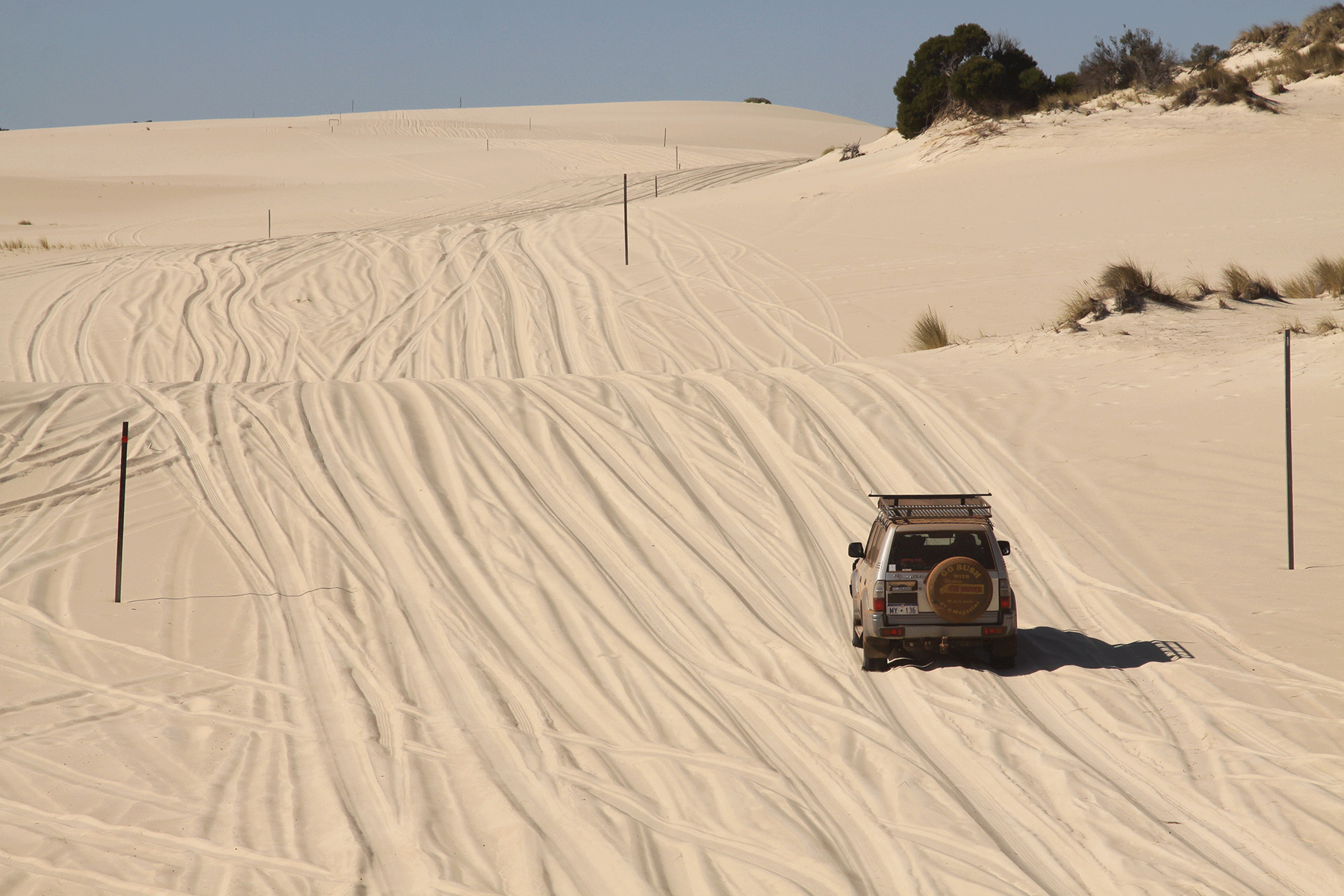
This 106km trek starts and ends in Pemberton and graded as difficult it’s best to do it alongside other experienced four-wheel drivers, particularly if you’re planning to do Callcup Hill and the Warren Beach drive. Both of these require high clearance, and lower tyre pressures if you’re going to drive across the dunes. Please note, camper trailers are not allowed on Warren Beach, and Callcup Hill is quite challenging, so unhitching or an RTT (or similar) may be preferred.
Check in with the rangers for the latest conditions before crossing the Warren River, as this can be dangerous no matter what time of year. And if you have any doubts, don’t do it.
Thankfully this track is a good one to travel no matter what time of year. If you’re after wildflowers, go in spring. Winter brings a few more challenges, as it can be very wet and windy and the Warren River mouth is frequently impassable during these months.
The journey
Departing from Pemberton on the Vasse Highway, then head south on the Pemberton-Northcliffe Road, passing the turn-off to Old Vasse Road. Head over the Warren River, pass Callcup Road and stay on the main road. Continue pass Allis Road, and not long after this (approximately 2km) you can veer left onto Malimup Track and then turn right onto Plantation Road.
The next stretch will have you veering right at two forks and crossing two bridges. Turn right onto Lewis Road and follow the signpost to Warren River. It’s along this stretch that the road becomes 4WD and you’ll need to lower your tyre pressures.
There’s a place to park at Callcup Hill where you can take a gander at the ‘hill’ and decide if you’ll make the trek down to the beach or not. It’s not just about deciding whether you’ll attempt the Warren Beach crossing. You need to be confident that you’ll be able to get back up the soft steep dunes of Callcup Hill.
If the conditions permit, there’s a right turn on the beach where you can cross the Warren River and access the Yeagarup Dunes. Please note, camper trailers are not permitted here. If you’re safe to continue, check conditions to make sure you can safely cross the river. January and February are the best times to do this. If the river has broken through, the water flows quickly and can be very deep in spots. Many rigs have had to be rescued due to failed crossings.
For those not attempting Callcup Hill, head back to Barker Road (around a 22km drive), where you’ll turn west. Continue along the track to Ritter Road, where you turn south to Yeagarup Lake. This is a great spot to stop, relax and let the tyres down. If you’ve come prepared, enjoy kayaking on the lake, or utilise the campsites available.
If you’ve got a camper, this is a perfect place to unhitch and follow the white trail-markers down to the Yeagarup Dunes. Don’t veer away from the markers, as you may get bogged and/or cause environmental damage. Once you’ve ticked off some beach driving, head back the way you came.
When leaving Yeagarup Lake, retrace your tyre tracks back to Ritter Road and continue on to the gravel old Vasse Road. Around 4km down this stretch you’ll spot a signpost to turn onto Heartbreak Trail – towing isn’t recommended here. But if you’re unladen, the one-way trail through Warren National Park offers two campsites, a number of day-use areas and an amazing lookout.
For those with a camper, continue following Old Vasse Road, turn right and head back to the Pemberton Northcliff Road for the short stint back to Pemberton, completing the loop.
Permits and fees
National Park entry and camping fees apply in Warren and D'Entrecasteaux national parks. For more information, head here.
Contact details
DBCA
P: 08 9776 1207
Pemberton Visitor Centre
P: 08 9776 1133
4. Francois Peron National Park
Starting in Denham, this 120km drive is graded medium. Offroad campers are permitted, and high-clearance, low-range vehicles will be required if you venture past Peron Homestead. It’s also advised to lower your tyre pressures to around 20psi.
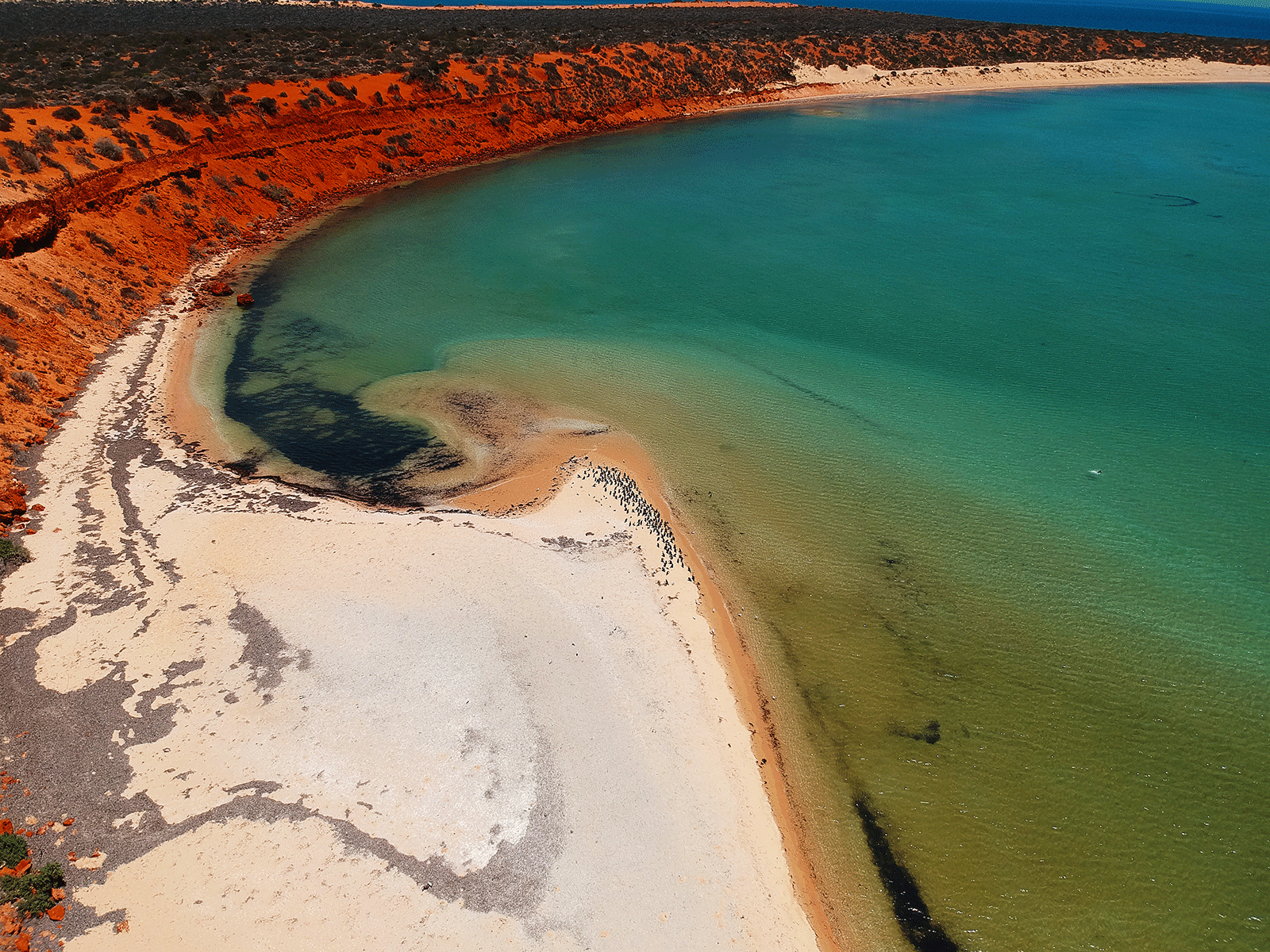
A unique feature of the area you’ll see is the salt-lagoon birrada (birridas). These were once land-locked slaine lakes, but after a drop in sea level the lakes dried and left salty hallows which support specially adapted plant and animal species. In some spots the sea has reflooded coastal birridas, creating inland bays such as Francois Peron National Parks’ renowned Big Lagoon and Little Lagoon.
It might go without saying, but do not drive on any birridas.
The journey
Anglers will love any adventures into the Francois Person National Park, so be sure to pack your rods.
There are designated camping areas on both sides of the peninsula. These tend to work on a first-come first-served basis (more information on these can be found here.)
Nature lovers will be in their element, particularly when it comes to spotting dugongs and migrating whales. Or head into the nearby Shark Bay region, which includes Monkey Mia’s famous dolphin viewing area.
Permits and fees
You’ll need a National Park entry and camping fee when entering Francois Peron National Park. This can be organised through the Department of Parkes and Wildlife Services (DPAW).
Contact details
DPAW
Gascoyne District Office
P: 08 9948 2226
5. Holland Track
The Holland Track runs between Hyden and Coolgardie, a 320km route that is graded medium. Allow at least two to three days to complete it. The best time to make the journey is in spring, when you’ll have the added bonus of a riot of wildflowers. Winters tend to be too wet, and summers to hot.
It is possible to tow a camper along Holland Track, but ensure it’s rated for offroad travel and be aware that there are some very tight spots.
The Holland Track was created after gold was discovered in Coolgardie in 1892 in an attempt to create a quicker path for prospectors. It took a few attempts, but in 1893, sandalwood collector and kangaroo shooter John Holland and his team cut the track from Broomehill to Coolgardie. This 500km route was used by countless gold hunters until the train system was completed in 1896. Following this, the bush slowly reclaimed the track.
In 1992, two Broomehill farmers — Graeme Newbey and Adrian Malloy — retraced Holland’s path and created the Holland Track as it is known today. As it became more popular among the four-wheel driving population, the Toyota LandCruiser Club of WA took responsibility for the track’s upkeep, and it is well signposted and maintained.
The route passes through the Great Western Woodland, so enjoy the spectacular scenery.
The journey
Not far after you leave Hyden you can enjoy a quick detour to WA’s iconic Wave Rock – a very impressive rock formation. After you’ve ticked this off your bucket list, continue along the Hyden-Norseman Road until you reach the Holland Track Centenary Plaque that marks the beginning of the track.
For the most part the track isn’t too difficult, but it does involve many twists and turns that will be hard work for anyone towing a camper. Rainfall can mean sections of the track have deep ruts, so if you don’t have high clearance, proceed with caution.
Check road conditions before departing, as recent or heavy rain can mean the track is quite slippery with mud and some mud holes may be impassable.
But if the conditions are in your favour, the trip up Mount Holland is well worth the adventure. It’s a steep but fairly straight drive to the peak and offers fantastic views of the area.
Ensure you follow all Holland Track signage when around Mount Holland, as there are some other mining roads that can cause confusion.
The remainder of the drive northeast along Holland Track is straightforward. Around 32km after Mount Holland you’ll spot a turn-off to Sandalwood Rocks where there’s a bush camping area. And at the Banker-Mount Day Road intersection make sure you stop and check out the plaque commemorating Holland and his exploration.
Further along the track you’ll find Diamond Rock which offers another bush camping location and a great walking trail. Or continue 2km along Holland Track to Thursday Rock, where there’s room for bush camping as well.
From this point, it’s another 19km until you reach Victoria Rock Road junction. Head north for 34km from the junction to reach Victoria Rock, which is a great place to set up camp with facilities including toilets and barbecues. Once you’ve enjoyed some rest and relaxation here, it’s a 45km drive to reach the journeys end at Coolgardie.
Contact details
Coolgardie Visitor Centre
P: 08 9026 6090
W: .coolgardie.wa.gov.au
DBCA Goldfields Regional Office
P: 08 9080 5555
W: parks.dpaw.wa.gov.au/park/goldfields-woodlands
Wave Rock Visitor Centre
P: 08 9880 5182
W: waverock.com.au
THE NEXT STEP
Are you ready to experience the freedom of the open road? Don't wait - Find your dream getaway now!
RELATED ARTICLES:
Tackling the Sandy Blight Junction Track, WA